

The relationship between the tigers, the deer as most important prey animals, the grasslands and the groundwater table of Bardiya National Park (BNP) is a complicated and vulnerable one. Shortly, major changes will take place in the river systems providing BNP with water. What effects these changes will have on the ecosystem of BNP is, however, unknown. Therefore the National Trust for Nature Conservation (NTNC), BNP park management and HTF want to have a better understanding of the hydrology of the Karnali and Babai rivers.
Dr. Jasper Griffioen, professor Water Quality Management at the Utrecht University, the Netherlands, will support this ambition by studying the hydrology of the park and its buffer zones in the years to come. In the last months of 2018, the MSc students Ewa van Kooten and Hanne Berghuis kicked off with collecting data on the rivers systems and the groundwater. Here, they report on their field studies.
Every day when we are cycling past Bardiya National Park, there is a couple of jeeps filled with tourists packed in their warm bubble coats waiting for the main entrance. The tourists face the cool morning breeze to go to one of the branches of the Karnali river. This is the place where most wildlife is spotted, including the imposing Bengal tiger. Obviously, because the river is an important drinking water source. However, it is not the only link between the tiger and the groundwater…
The Karnali river is one of the main rivers of Nepal and flows along the west side of Bardiya National Park. During the monsoon the Karnali bursts its banks and a part of the park is flooded. Even the vegetation can be washed away by the power of the water, resetting the area to an early stage of the succession: grasslands. These grasslands are not only the habitat for rhinos and elephants but also for the deer – the most important prey of the tiger. In other words: no tigers without grasslands. While flood enables the growth of the grasslands by resetting the vegetation to an early stage of the succession, a high groundwater table prevents encroachment of scrubs and trees on the grasslands.
In the past years, a change has occurred in the flowing path of the river. Just upstream the park, the river bifurcates. Until a few years ago, the bulk of the water was flowing to Bardiya National park, through the eastern branch. Now, the main channel has shifted to the western branch. The change is clearly visible in the satellite images (figure 1). How exactly this influences the water availability of the park is yet unclear. That’s why the Himalayan Tiger Foundation in cooperation with NTNC took the initiative to dive into the hydrology of Bardiya and we have the honour to kick off this project. This September, we have started our final research project about the hydrology of the national park for our master Earth, Surface and Water at Utrecht University. Ewa examines the Karnali River and Hanne focusses on the groundwater, both supervised by Jasper Griffioen, Derek Karssenberg and Piet Veel.
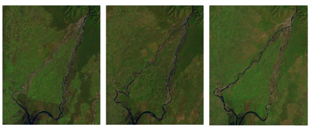
Figure 1. Satellite images of the Karnali River showing the shift of the main channel.
From left to right: March 1990, March 1995 and March 2016.
Karnali River
The aim of the research at the Karnali River is to understand why the main channel has shifted to the western branch and what the consequences of this event are for the water stages and discharge of the part of the river that flows through the park. There are several factors, which might have played a role, both natural and human induced. Large rivers like the Karnali transport a lot of sediment out of the Himalayas which will be deposited further downstream at the foot of the most southern hills in the river or its floodplain. The deposition of sediment constantly changes the flow path of the river. The photo shows how the sediments hinder the waterflow towards the eastern branch at the bifurcation of the Karnali (figure 2). This sediment is deposited here by the river and can be eroded again by the next severe flood event. Besides this natural phenomenon, the river flow is also influenced by gravel mining and water extraction for irrigation.
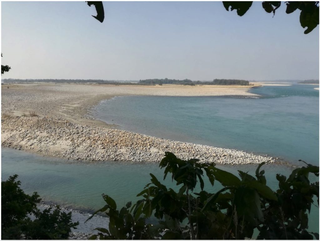
Figure 2: The bifurcation of the Karnali River. The branch at the right side is flowing towards the west. The branch in the middle is flowing towards east. At this branch, the water is hindered by the sediment. The branch at the left side is also flowing towards the east. This branch is dug out by the park management in other to provide water for the park.
It is not yet known to which extend the river is influenced by these factors. To get insight in the relative importance of these processes, we will construct a computer model of the river which is able to simulate the above-mentioned factors. The calibration of the model requires data, which we were collecting during our field work in Nepal. It is important to know the discharge of the river at different times and locations. The discharge is calculated based on the depth profile of the river and the flow velocity. We usually measure this from a bridge but there are not bridges everywhere. At these spots NTNC allows us to use their elephant “Santikilididi” (Santikili is her name and didi means sister). From Santikilididi we can wade through the strong currents while she protects us from wild tigers, elephants and rhinos at the same time. Besides the discharge measurements, we also map characteristics such as elevation, vegetation and sediment size at the bifurcation, since these determine how the water is divided over the two branches.
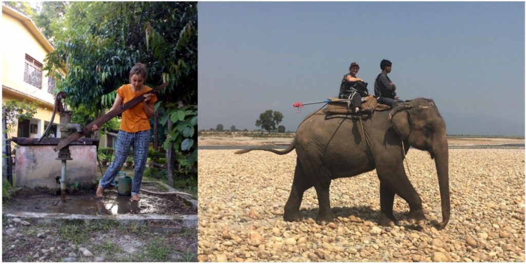
Figure 3: Left: Hanne is unscrewing a handpump in order to install a pressure transducer. Right: Ewa is sitting on the elephant, ready to measure the water depth and velocity.
Groundwater
Then the question arises, how does the Karnali influences the level of the groundwater? To answer this question, it is essential to know how and where the groundwater aquifer recharges and discharges. You can think about processes such as rainwater infiltration, transport from the upland, in- and outflow of various rivers, evaporation and human influences such as irrigation. In the three months that we were in Nepal we collected as much data as possible about these processes. Starting with a chemical analysis of groundwater samples at different locations. Based on stable isotope analysis, we will first track down the origin of the water: does the water mainly consist of rainwater or of meltwater from the Karnali River? Then, we will look at the chemical water composition to estimate whether the sampled water has had a long journey through the subsurface or a river. The flow underneath the surface and the infiltration are highly dependent on the subsurface properties. We map these properties by performing pump tests and drilling in the subsurface with a hand auger. Also, we make use of local knowledge and data. Last but not least, we monitor the groundwater level using so-called pressure transducers, which automatically measure the groundwater level every 15 minutes. We have installed these devices in various – abandoned or not – handpumps (figure 3). At the end of the fieldwork we had some struggles to obtain all data from the pressure transducers but a valuable and unique dataset was obtained. This data provides information about how much the groundwater level drops between the wet and the dry season and how this spatially varies. Back home, we hope to get an overview of the groundwater system.
Hopefully other master students or maybe even a PhD-student will finish the work we have started, to answer the ultimate question: How can water management improve the habitat of the Bengal tiger?